Thank you for supporting this site ❤️
Make a donation
Make a donation
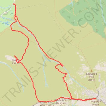
Dodd, Whiteside East Top, Gasgale Crags Summit and Hopegill Head Loop Hike
- Distance: 8.7 Km
- Elevation gain: 649 m
- Maximum elevation: 748 m
- Elevation loss: 653 m
- Minimum elevation: 177 m
- Moving time: 2 h 49 m
- Moving speed: 3.1 Km/h
- Maximum speed: 13.4 Km/h
- Total time: 5 h 22 m
- Global speed: 1.6 Km/h
Interactive trail map
Thank you for supporting this site ❤️
Make a donation
Make a donation
Trail profile
- Distance: 8.7 Km
- Elevation gain: 649 m
- Maximum elevation: 748 m
- Elevation loss: 653 m
- Minimum elevation: 177 m
- Moving time: 2 h 49 m
- Moving speed: 3.1 Km/h
- Maximum speed: 13.4 Km/h
- Total time: 5 h 22 m
- Global speed: 1.6 Km/h
Thank you for supporting this site ❤️
Make a donation
Make a donation
About this trail
Name: Dodd, Whiteside East Top, Gasgale Crags Summit and Hopegill Head Loop Hike trail, distance, elevation, map, profile, GPS track
Start: B5292, High Lorton, Lorton, Cumberland, England, CA13 9UA, United Kingdom (54.60582 -3.28824)
End: Lorton, Cumberland, England, CA13 9UD, United Kingdom (54.60578 -3.28849)
Coordinates: 54.58738 -3.28942 54.60587 -3.26171
Thank you for supporting this site ❤️
Make a donation
Make a donation