Thank you for supporting this site ❤️
Make a donation
Make a donation
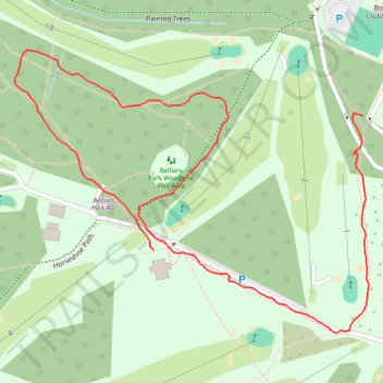
Belfairs Park walk
- Distance: 1.4 Km
- Elevation gain: 11 m
- Maximum elevation: 58 m
- Elevation loss: 12 m
- Minimum elevation: 49 m
- Moving time: 21 m 21 s
- Moving speed: 3.8 Km/h
- Maximum speed: 6.1 Km/h
- Total time: 23 m 49 s
- Global speed: 3.4 Km/h
Interactive trail map
Thank you for supporting this site ❤️
Make a donation
Make a donation
Trail profile
- Distance: 1.4 Km
- Elevation gain: 11 m
- Maximum elevation: 58 m
- Elevation loss: 12 m
- Minimum elevation: 49 m
- Moving time: 21 m 21 s
- Moving speed: 3.8 Km/h
- Maximum speed: 6.1 Km/h
- Total time: 23 m 49 s
- Global speed: 3.4 Km/h
Thank you for supporting this site ❤️
Make a donation
Make a donation
About this trail
Name: Belfairs Park walk trail, distance, elevation, map, profile, GPS track
Start: Painted Trees, Hadleigh, Southend-on-Sea, Essex, England, SS9 4TQ, United Kingdom (51.55769 0.64384)
Coordinates: 51.55541 0.63796 51.55838 0.64394
Thank you for supporting this site ❤️
Make a donation
Make a donation