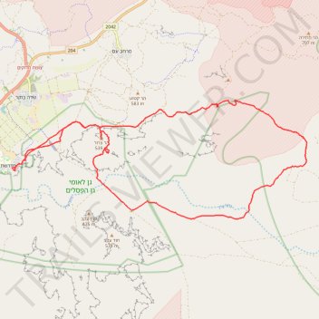
קישור בין נחל דרוך לנחל תלול
- Distance: 32.3 Km
- Elevation gain: 672 m
- Maximum elevation: 627 m
- Elevation loss: 671 m
- Minimum elevation: 266 m
- Moving time: 5 h 50 m
- Moving speed: 5.5 Km/h
- Maximum speed: 12.7 Km/h
- Total time: 7 h 42 m
- Global speed: 4.2 Km/h
Interactive trail map
Trail profile
About this trail
Name: קישור בין נחל דרוך לנחל תלול trail, distance, elevation, map, profile, GPS track
Coordinates: 30.83409 34.78751 30.87272 34.89902
Topography: Ramat Negev Regional Council topographic map, elevation, terrain
Other hiking, mountain biking, running and outdoor activity trails
Click on a trail to view its statistics, map and profile.
קישור בין נחל זקוף לנחל דרוך
Israel > South District > Ramat Negev Regional Council > Merchav Am
Distance: 38.0 Km • Elevation gain: 839 m • Maximum elevation: 675 m