Thank you for supporting this site ❤️
Make a donation
Make a donation
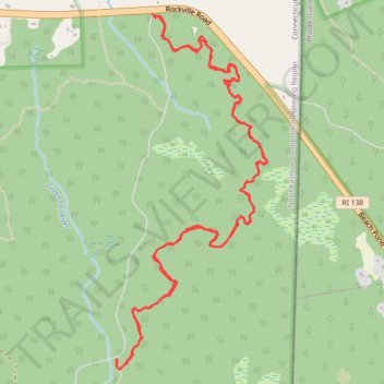
Yellow blazed hiking trail in Green Falls Pond area of Pachaug State Park
- Distance: 7.6 Km
- Elevation gain: 73 m
- Maximum elevation: 157 m
- Elevation loss: 73 m
- Minimum elevation: 123 m
- Moving time: 2 h 4 m
- Moving speed: 3.7 Km/h
- Maximum speed: 5.9 Km/h
- Total time: 2 h 56 m
- Global speed: 2.6 Km/h
Interactive trail map
Thank you for supporting this site ❤️
Make a donation
Make a donation
Trail profile
- Distance: 7.6 Km
- Elevation gain: 73 m
- Maximum elevation: 157 m
- Elevation loss: 73 m
- Minimum elevation: 123 m
- Moving time: 2 h 4 m
- Moving speed: 3.7 Km/h
- Maximum speed: 5.9 Km/h
- Total time: 2 h 56 m
- Global speed: 2.6 Km/h
Thank you for supporting this site ❤️
Make a donation
Make a donation
About this trail
Name: Yellow blazed hiking trail in Green Falls Pond area of Pachaug State Park trail, distance, elevation, map, profile, GPS track
Coordinates: 41.54248 -71.80194 41.55815 -71.79298
Thank you for supporting this site ❤️
Make a donation
Make a donation
Other hiking, mountain biking, running and outdoor activity trails
Click on a trail to view its statistics, map and profile.
Green Falls Area North East Loop - Pachaug State Forest
United States > Connecticut > Northeastern Connecticut Planning Region > Voluntown
Distance: 9.1 Km • Elevation gain: 75 m • Maximum elevation: 157 m