The Large Crater
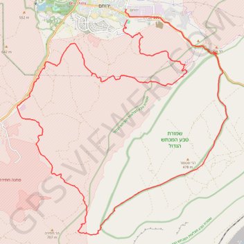
Interactive trail map
Trail profile
- Distance: 47.1 Km
- Elevation gain: 861 m
- Maximum elevation: 693 m
- Elevation loss: 868 m
- Minimum elevation: 350 m
About this trail
Name: The Large Crater trail, distance, elevation, map, profile, GPS track
Start: Rashi, Shaked, Yerocham, Yeruham, Beersheba Subdistrict, South District, Israel (30.98295 34.93638)
Coordinates: 30.89231 34.88217 30.98745 34.98566
Topography: Yeruham topographic map, elevation, terrain
Other hiking, mountain biking, running and outdoor activity trails
Click on a trail to view its statistics, map and profile.
Nahal Shualim to Midreshet Ben-Gurion
Israel > South District > Yeruham
נחל שועלים ורכס חתירה: קו גדול מירוחם למדרשת בן גוריון דרך נחל דרוך
Distance: 38.1 Km • Elevation gain: 840 m • Maximum elevation: 687 m
Yeruham Crater to Midreshet Ben Gurion
Israel > South District > Ramat Negev Regional Council
מכתש ירוחם למדרשת בן גוריון: מכתש גדול וטעימה ממדבר צין
Distance: 34.3 Km • Elevation gain: 1,311 m • Maximum elevation: 679 m
חיתוך בתוך המכתש הגדול, מנחל חתירה לסנפיר
Israel > South District > Ramat Negev Regional Council
Distance: 33.1 Km • Elevation gain: 1,105 m • Maximum elevation: 681 m
Yeruham Crater - Karbolet
Israel > South District > Ramat Negev Regional Council
מכתש ירוחם והר כרבולת: מעגלי קטן בתוך המכתש הגדול
Distance: 18.9 Km • Elevation gain: 649 m • Maximum elevation: 571 m
Yeruham Crater Circle
Israel > South District > Ramat Negev Regional Council
סובב מכתש ירוחם: קו פנורמי, אלגנטי וגדול סביב תופעת טבע עוצרת נשימה
Distance: 40.4 Km • Elevation gain: 1,586 m • Maximum elevation: 687 m
קישור בין נחל זקוף לנחל דרוך
Israel > South District > Ramat Negev Regional Council > Merchav Am
Distance: 38.0 Km • Elevation gain: 839 m • Maximum elevation: 675 m