קישור בין נחל זקוף לנחל דרוך
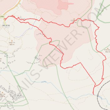
- Distance: 38.0 Km
- Elevation gain: 839 m
- Maximum elevation: 675 m
- Elevation loss: 837 m
- Minimum elevation: 228 m
- Moving time: 7 h 30 m
- Moving speed: 5.1 Km/h
- Maximum speed: 13.9 Km/h
- Total time: 9 h 18 m
- Global speed: 4.1 Km/h
Interactive trail map
Trail profile
About this trail
Name: קישור בין נחל זקוף לנחל דרוך trail, distance, elevation, map, profile, GPS track
Coordinates: 30.82676 34.82693 30.89751 34.93260
Topography: Ramat Negev Regional Council topographic map, elevation, terrain
Other hiking, mountain biking, running and outdoor activity trails
Click on a trail to view its statistics, map and profile.
קישור בין נחל דרוך לנחל תלול
Israel > South District > Ramat Negev Regional Council > Midreshet Ben-Gurion
Distance: 32.3 Km • Elevation gain: 672 m • Maximum elevation: 627 m
חיתוך בתוך המכתש הגדול, מנחל חתירה לסנפיר
Israel > South District > Ramat Negev Regional Council
Distance: 33.1 Km • Elevation gain: 1,105 m • Maximum elevation: 681 m