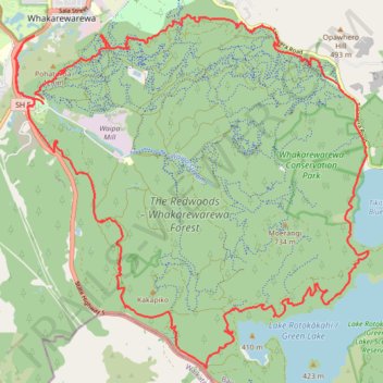
The Redwoods - Whakarewarewa Forest Loop Mountain Biking
- Distance: 40.4 Km
- Elevation gain: 1,146 m
- Maximum elevation: 516 m
- Elevation loss: 1,144 m
- Minimum elevation: 310 m
- Moving time: 2 h 44 m
- Moving speed: 14.7 Km/h
- Maximum speed: 43.1 Km/h
- Total time: 2 h 57 m
- Global speed: 13.7 Km/h
Interactive trail map
Trail profile
- Distance: 40.4 Km
- Elevation gain: 1,146 m
- Maximum elevation: 516 m
- Elevation loss: 1,144 m
- Minimum elevation: 310 m
- Moving time: 2 h 44 m
- Moving speed: 14.7 Km/h
- Maximum speed: 43.1 Km/h
- Total time: 2 h 57 m
- Global speed: 13.7 Km/h
About this trail
Name: The Redwoods - Whakarewarewa Forest Loop Mountain Biking trail, distance, elevation, map, profile, GPS track
Coordinates: -38.22448 176.24571 -38.15945 176.32840
Other hiking, mountain biking, running and outdoor activity trails
Click on a trail to view its statistics, map and profile.
The Redwoods - Whakarewarewa Forest Mountain Biking - Forest Loop
New Zealand > Bay of Plenty > Rotorua Lakes District > Rotorua
Distance: 35.1 Km • Elevation gain: 1,069 m • Maximum elevation: 517 m