Brisbane Koala Bushlands Loop Run
- Distance: 21.2 Km
- Elevation gain: 310 m
- Maximum elevation: 87 m
- Elevation loss: 309 m
- Minimum elevation: 22 m
- Moving time: 2 h 33 m
- Moving speed: 8.3 Km/h
- Maximum speed: 13.5 Km/h
- Total time: 2 h 34 m
- Global speed: 8.2 Km/h
Interactive trail map
Trail profile
- Distance: 21.2 Km
- Elevation gain: 310 m
- Maximum elevation: 87 m
- Elevation loss: 309 m
- Minimum elevation: 22 m
- Moving time: 2 h 33 m
- Moving speed: 8.3 Km/h
- Maximum speed: 13.5 Km/h
- Total time: 2 h 34 m
- Global speed: 8.2 Km/h
About this trail
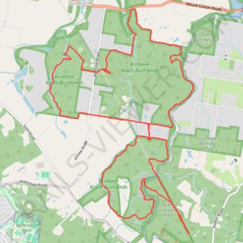
Name: Brisbane Koala Bushlands Loop Run trail, distance, elevation, map, profile, GPS track
Start: Horse Trail, Burbank, Greater Brisbane, Queensland, 4156, Australia (-27.57056 153.16390)
Coordinates: -27.60012 153.15271 -27.55958 153.18195
Other hiking, mountain biking, running and outdoor activity trails
Click on a trail to view its statistics, map and profile.
Eastern Escarpment Conservation Area, Venman Bushland National Park, Daisy Hill Conservation Park, Koala Bushland Conservation Area and Neville Lawrie Reserve loop
Australia > Queensland > Brisbane
Distance: 26.3 Km • Elevation gain: 599 m • Maximum elevation: 218 m