Three Lakes Loop (Teatown Lake, Vernay Lake and Shadow Lake) via Briarcliff-Peekskill Trail
Description:
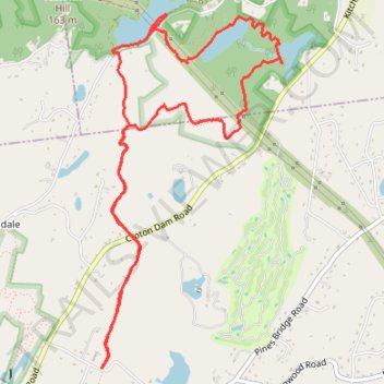
- Distance: 9.3 Km
- Elevation gain: 210 m
- Maximum elevation: 182 m
- Elevation loss: 210 m
- Minimum elevation: 102 m
- Moving time: 1 h 56 m
- Moving speed: 4.8 Km/h
- Maximum speed: 9.9 Km/h
- Total time: 1 h 59 m
- Global speed: 4.7 Km/h
Interactive trail map
Trail profile
- Distance: 9.3 Km
- Elevation gain: 210 m
- Maximum elevation: 182 m
- Elevation loss: 210 m
- Minimum elevation: 102 m
- Moving time: 1 h 56 m
- Moving speed: 4.8 Km/h
- Maximum speed: 9.9 Km/h
- Total time: 1 h 59 m
- Global speed: 4.7 Km/h
About this trail
Name: Three Lakes Loop (Teatown Lake, Vernay Lake and Shadow Lake) via Briarcliff-Peekskill Trail trail, distance, elevation, map, profile, GPS track
Coordinates: 41.18749 -73.83620 41.21077 -73.82047
Other hiking, mountain biking, running and outdoor activity trails
Click on a trail to view its statistics, map and profile.
Teatown Lake Reservation: Overlook Trail, Hidden Valley Loop and Phenology Trail
United States > New York > Westchester County > Town of Yorktown > Glendale
Distance: 7.0 Km • Elevation gain: 157 m • Maximum elevation: 179 m