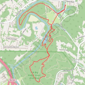
Greenway Farms loop
- Distance: 7.7 Km
- Elevation gain: 199 m
- Maximum elevation: 306 m
- Elevation loss: 199 m
- Minimum elevation: 198 m
- Moving time: 1 h 49 m
- Moving speed: 4.2 Km/h
- Maximum speed: 6.9 Km/h
- Total time: 1 h 49 m
- Global speed: 4.2 Km/h
Interactive trail map
Trail profile
- Distance: 7.7 Km
- Elevation gain: 199 m
- Maximum elevation: 306 m
- Elevation loss: 199 m
- Minimum elevation: 198 m
- Moving time: 1 h 49 m
- Moving speed: 4.2 Km/h
- Maximum speed: 6.9 Km/h
- Total time: 1 h 49 m
- Global speed: 4.2 Km/h
About this trail
Name: Greenway Farms loop trail, distance, elevation, map, profile, GPS track
Coordinates: 35.11148 -85.22751 35.12890 -85.21492
Other hiking, mountain biking, running and outdoor activity trails
Click on a trail to view its statistics, map and profile.
TVA Big Ridge Small Wild Area Loop Trails from Greenway Farms
United States > Tennessee > Hamilton County > Chattanooga
Distance: 9.7 Km • Elevation gain: 273 m • Maximum elevation: 307 m