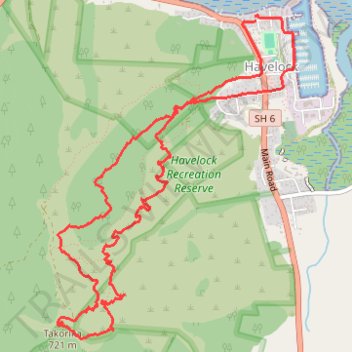
Takorika Summit loop - Havelock
- Distance: 10.0 Km
- Elevation gain: 758 m
- Maximum elevation: 704 m
- Elevation loss: 762 m
- Minimum elevation: 1 m
- Moving time: 3 h 3 m
- Moving speed: 3.3 Km/h
- Maximum speed: 7.3 Km/h
- Total time: 4 h 1 m
- Global speed: 2.5 Km/h
Interactive trail map
Trail profile
- Distance: 10.0 Km
- Elevation gain: 758 m
- Maximum elevation: 704 m
- Elevation loss: 762 m
- Minimum elevation: 1 m
- Moving time: 3 h 3 m
- Moving speed: 3.3 Km/h
- Maximum speed: 7.3 Km/h
- Total time: 4 h 1 m
- Global speed: 2.5 Km/h
About this trail
Name: Takorika Summit loop - Havelock trail, distance, elevation, map, profile, GPS track
Start: 7, Cook Street, Havelock, Marlborough District, Marlborough, 7100, New Zealand (-41.27562 173.76635)
End: 8, Cook Street, Havelock, Marlborough District, Marlborough, 7100, New Zealand (-41.27526 173.76630)
Coordinates: -41.29663 173.74889 -41.27508 173.76976
Other hiking, mountain biking, running and outdoor activity trails
Click on a trail to view its statistics, map and profile.