Thank you for supporting this site ❤️
Make a donation
Make a donation
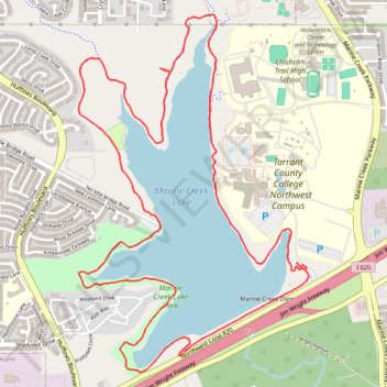
Marine Creek Lake Loop, new sidewalk
- Distance: 10.0 Km
- Elevation gain: 56 m
- Maximum elevation: 222 m
- Elevation loss: 55 m
- Minimum elevation: 211 m
- Moving time: 1 h 54 m
- Moving speed: 5.2 Km/h
- Maximum speed: 8.6 Km/h
- Total time: 1 h 55 m
- Global speed: 5.2 Km/h
Interactive trail map
Thank you for supporting this site ❤️
Make a donation
Make a donation
Trail profile
- Distance: 10.0 Km
- Elevation gain: 56 m
- Maximum elevation: 222 m
- Elevation loss: 55 m
- Minimum elevation: 211 m
- Moving time: 1 h 54 m
- Moving speed: 5.2 Km/h
- Maximum speed: 8.6 Km/h
- Total time: 1 h 55 m
- Global speed: 5.2 Km/h
Thank you for supporting this site ❤️
Make a donation
Make a donation
About this trail
Name: Marine Creek Lake Loop, new sidewalk trail, distance, elevation, map, profile, GPS track
Start: TCC Lakeside Drive, Fort Worth, Tarrant County, Texas, 76179, United States (32.82658 -97.38991)
End: TCC Lakeside Drive, Fort Worth, Tarrant County, Texas, 76179, United States (32.82678 -97.38985)
Coordinates: 32.82034 -97.40513 32.84143 -97.38902
Thank you for supporting this site ❤️
Make a donation
Make a donation