Thank you for supporting this site ❤️
Make a donation
Make a donation
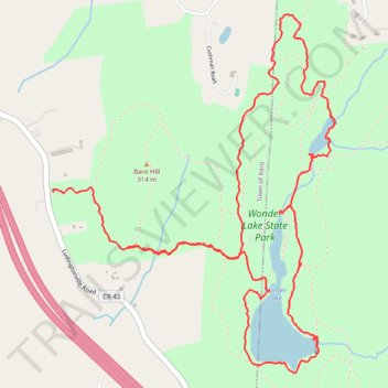
Wonder Lake State Park loop hike
- Distance: 9.0 Km
- Elevation gain: 160 m
- Maximum elevation: 328 m
- Elevation loss: 219 m
- Minimum elevation: 207 m
- Moving time: 3 h 2 m
- Moving speed: 2.9 Km/h
- Maximum speed: 9.1 Km/h
- Total time: 4 h 47 m
- Global speed: 1.9 Km/h
Interactive trail map
Thank you for supporting this site ❤️
Make a donation
Make a donation
Trail profile
- Distance: 9.0 Km
- Elevation gain: 160 m
- Maximum elevation: 328 m
- Elevation loss: 219 m
- Minimum elevation: 207 m
- Moving time: 3 h 2 m
- Moving speed: 2.9 Km/h
- Maximum speed: 9.1 Km/h
- Total time: 4 h 47 m
- Global speed: 1.9 Km/h
Thank you for supporting this site ❤️
Make a donation
Make a donation
About this trail
Name: Wonder Lake State Park loop hike trail, distance, elevation, map, profile, GPS track
Coordinates: 41.48609 -73.66282 41.50343 -73.64462
Thank you for supporting this site ❤️
Make a donation
Make a donation
Other hiking, mountain biking, running and outdoor activity trails
Click on a trail to view its statistics, map and profile.