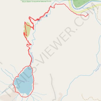
Lake Twentytwo Loop
- Distance: 9.4 Km
- Elevation gain: 440 m
- Maximum elevation: 760 m
- Elevation loss: 527 m
- Minimum elevation: 343 m
- Moving time: 3 h 18 m
- Moving speed: 2.8 Km/h
- Maximum speed: 8.3 Km/h
- Total time: 3 h 55 m
- Global speed: 2.4 Km/h
Interactive trail map
Trail profile
- Distance: 9.4 Km
- Elevation gain: 440 m
- Maximum elevation: 760 m
- Elevation loss: 527 m
- Minimum elevation: 343 m
- Moving time: 3 h 18 m
- Moving speed: 2.8 Km/h
- Maximum speed: 8.3 Km/h
- Total time: 3 h 55 m
- Global speed: 2.4 Km/h
About this trail
Name: Lake Twentytwo Loop trail, distance, elevation, map, profile, GPS track
Start: Lake Twenty Two Trail, Verlot, Snohomish County, Washington, United States (48.07807 -121.75556)
Coordinates: 48.06102 -121.76724 48.07883 -121.74585
Other hiking, mountain biking, running and outdoor activity trails
Click on a trail to view its statistics, map and profile.
Lake Twentytwo Loop in Mount Baker-Snoqualmie National Forest
United States > Washington > Snohomish County
The Lake Twentytwo Loop offers a picturesque hiking experience that immerses you in the lush, moss-draped forests typical of the Pacific Northwest. The trail leads through dense old-growth forests, crossing streams and small waterfalls, before opening to rocky fields where the surrounding peaks, including…
Distance: 9.6 Km • Elevation gain: 514 m • Maximum elevation: 759 m
Northern part of the Pacific Crest Trail (PCT)
United States > Oregon > Klamath County
Hike on the Pacific Crest National Scenic Trail from Crater Lake to Canada Border through Oregon and Washington along the Sierra Nevada and Cascade mountain ranges. #Hiking #Mountain #SierraNevada #Cascade #Nature #Forest #Park #PCT
Distance: 1,198.3 Km • Elevation gain: 44,308 m • Maximum elevation: 2,307 m