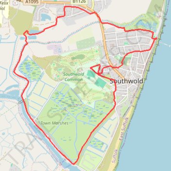
Southwold and Reydon Loop
- Distance: 7.4 Km
- Elevation gain: 31 m
- Maximum elevation: 14 m
- Elevation loss: 31 m
- Minimum elevation: -2 m
- Moving time: 1 h 51 m
- Moving speed: 4.0 Km/h
- Maximum speed: 6.4 Km/h
- Total time: 2 h 17 m
- Global speed: 3.2 Km/h
Interactive trail map
Trail profile
- Distance: 7.4 Km
- Elevation gain: 31 m
- Maximum elevation: 14 m
- Elevation loss: 31 m
- Minimum elevation: -2 m
- Moving time: 1 h 51 m
- Moving speed: 4.0 Km/h
- Maximum speed: 6.4 Km/h
- Total time: 2 h 17 m
- Global speed: 3.2 Km/h
About this trail
Name: Southwold and Reydon Loop trail, distance, elevation, map, profile, GPS track
Start: York Road, Southwold, East Suffolk, Suffolk, England, IP18 6TB, United Kingdom (52.32756 1.67243)
End: York Road, Southwold, East Suffolk, Suffolk, England, IP18 6TB, United Kingdom (52.32754 1.67238)
Coordinates: 52.31624 1.65781 52.33478 1.68514
Other hiking, mountain biking, running and outdoor activity trails
Click on a trail to view its statistics, map and profile.
Suffolk Coast Path - Dunwich to Walberwick Loop
United Kingdom > England > Suffolk > East Suffolk > Dunwich
Distance: 22.4 Km • Elevation gain: 125 m • Maximum elevation: 22 m