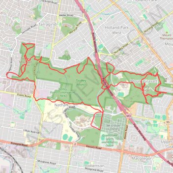
Mount Gravatt and Toohey Foret Loop
- Distance: 26.1 Km
- Elevation gain: 785 m
- Maximum elevation: 187 m
- Elevation loss: 783 m
- Minimum elevation: 33 m
- Moving time: 3 h 47 m
- Moving speed: 6.9 Km/h
- Maximum speed: 13.3 Km/h
- Total time: 4 h 4 m
- Global speed: 6.4 Km/h
Interactive trail map
Trail profile
- Distance: 26.1 Km
- Elevation gain: 785 m
- Maximum elevation: 187 m
- Elevation loss: 783 m
- Minimum elevation: 33 m
- Moving time: 3 h 47 m
- Moving speed: 6.9 Km/h
- Maximum speed: 13.3 Km/h
- Total time: 4 h 4 m
- Global speed: 6.4 Km/h
About this trail
Name: Mount Gravatt and Toohey Foret Loop trail, distance, elevation, map, profile, GPS track
Coordinates: -27.55515 153.03092 -27.53184 153.07955
Other hiking, mountain biking, running and outdoor activity trails
Click on a trail to view its statistics, map and profile.
Gravel loop ride via Karawatha
Australia > Queensland > City of Brisbane
Distance: 60.4 Km • Elevation gain: 620 m • Maximum elevation: 110 m
Toohey Forest Loop
Australia > Queensland > City of Brisbane
Distance: 7.9 Km • Elevation gain: 185 m • Maximum elevation: 110 m
Brisbane - Karawatha
Distance: 22.2 Km • Elevation gain: 239 m • Maximum elevation: 89 m