Ben Shemen Hertzel Blue Single
סינגל כחול משודרג ביער בן שמן
- Distance: 10.9 Km
- Elevation gain: 197 m
- Maximum elevation: 176 m
- Elevation loss: 197 m
- Minimum elevation: 92 m
- Moving time: 57 m 35 s
- Moving speed: 11.4 Km/h
- Maximum speed: 39.3 Km/h
- Total time: 58 m 58 s
- Global speed: 11.1 Km/h
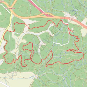
Interactive trail map
Trail profile
- Distance: 10.9 Km
- Elevation gain: 197 m
- Maximum elevation: 176 m
- Elevation loss: 197 m
- Minimum elevation: 92 m
- Moving time: 57 m 35 s
- Moving speed: 11.4 Km/h
- Maximum speed: 39.3 Km/h
- Total time: 58 m 58 s
- Global speed: 11.1 Km/h
About this trail
Name: Ben Shemen Hertzel Blue Single trail, distance, elevation, map, profile, GPS track
Start: Hevel Modiin Regional Council, Ramla Subdistrict, Center District, Israel (31.95005 34.95544)
End: Hevel Modiin Regional Council, Ramla Subdistrict, Center District, Israel (31.94990 34.95542)
Coordinates: 31.94058 34.93756 31.95144 34.95980
Topography: Center District topographic map, elevation, terrain
Other hiking, mountain biking, running and outdoor activity trails
Click on a trail to view its statistics, map and profile.
מסלול חדש ומטורף. אהבתי.
Distance: 20.3 Km • Elevation gain: 284 m • Maximum elevation: 142 m