Make a donation
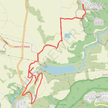
Cycling from Tefahot to Eilabun
- Distance: 11.5 Km
- Elevation gain: 249 m
- Maximum elevation: 128 m
- Elevation loss: 249 m
- Minimum elevation: 42 m
- Moving time: 1 h 12 m
- Moving speed: 9.5 Km/h
- Maximum speed: 43.7 Km/h
- Total time: 1 h 55 m
- Global speed: 6.0 Km/h
Interactive trail map
Make a donation
Trail profile
- Distance: 11.5 Km
- Elevation gain: 249 m
- Maximum elevation: 128 m
- Elevation loss: 249 m
- Minimum elevation: 42 m
- Moving time: 1 h 12 m
- Moving speed: 9.5 Km/h
- Maximum speed: 43.7 Km/h
- Total time: 1 h 55 m
- Global speed: 6.0 Km/h
Make a donation
About this trail
Name: Cycling from Tefahot to Eilabun trail, distance, elevation, map, profile, GPS track
Coordinates: 32.84194 35.40054 32.86875 35.42076
Topography: Merom HaGalil Regional Council topographic map, elevation, terrain
Make a donation
Other hiking, mountain biking, running and outdoor activity trails
Click on a trail to view its statistics, map and profile.
Cycling from tefahot to hazon and back through maghar
Israel > North District > Merom HaGalil Regional Council > Tefahot
Distance: 15.7 Km • Elevation gain: 404 m • Maximum elevation: 387 m
Cycling from Tefahot to Migdal and back
Israel > North District > Merom HaGalil Regional Council > Tefahot
Distance: 35.5 Km • Elevation gain: 551 m • Maximum elevation: 120 m
Cycling from Tefahot to the Kineret
Israel > North District > Merom HaGalil Regional Council > Tefahot
Distance: 18.9 Km • Elevation gain: 315 m • Maximum elevation: 126 m
Cycling from the Kineret to Tefahot
Israel > North District > Emek HaYarden Regional Council
Distance: 21.0 Km • Elevation gain: 479 m • Maximum elevation: 119 m
Make a donation
MTB cycling from Tefahot to Masad
Israel > North District > Merom HaGalil Regional Council > Tefahot
Distance: 16.6 Km • Elevation gain: 429 m • Maximum elevation: 298 m
Cycling from Tefahot to Eilabun
Israel > North District > Merom HaGalil Regional Council > Tefahot
Distance: 12.1 Km • Elevation gain: 278 m • Maximum elevation: 158 m
MTB cycling track near Maghar
Israel > North District > Merom HaGalil Regional Council > Tefahot
Distance: 9.0 Km • Elevation gain: 122 m • Maximum elevation: 115 m