Venman and Daisy parks
- Distance: 19.1 Km
- Elevation gain: 376 m
- Maximum elevation: 139 m
- Elevation loss: 358 m
- Minimum elevation: 28 m
- Moving time: 2 h 19 m
- Moving speed: 8.2 Km/h
- Maximum speed: 15.4 Km/h
- Total time: 2 h 21 m
- Global speed: 8.1 Km/h
Interactive trail map
Trail profile
- Distance: 19.1 Km
- Elevation gain: 376 m
- Maximum elevation: 139 m
- Elevation loss: 358 m
- Minimum elevation: 28 m
- Moving time: 2 h 19 m
- Moving speed: 8.2 Km/h
- Maximum speed: 15.4 Km/h
- Total time: 2 h 21 m
- Global speed: 8.1 Km/h
About this trail
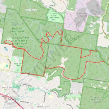
Name: Venman and Daisy parks trail, distance, elevation, map, profile, GPS track
Start: Jacks Track, Mount Cotton, Greater Brisbane, Queensland, 4165, Australia (-27.62636 153.20098)
End: Venman Road, Mount Cotton, Greater Brisbane, Queensland, 4165, Australia (-27.63196 153.20484)
Coordinates: -27.64000 153.15229 -27.61684 153.20484
Other hiking, mountain biking, running and outdoor activity trails
Click on a trail to view its statistics, map and profile.
Eastern Escarpment Conservation Area, Venman Bushland National Park, Daisy Hill Conservation Park, Koala Bushland Conservation Area and Neville Lawrie Reserve loop
Australia > Queensland > Brisbane
Distance: 26.3 Km • Elevation gain: 599 m • Maximum elevation: 218 m
Venman and Daisy Loop
Distance: 18.2 Km • Elevation gain: 250 m • Maximum elevation: 139 m
Daisy Hill Loop
Distance: 16.8 Km • Elevation gain: 290 m • Maximum elevation: 119 m