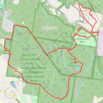
Daisy Hill Loop
- Distance: 16.8 Km
- Elevation gain: 290 m
- Maximum elevation: 119 m
- Elevation loss: 289 m
- Minimum elevation: 56 m
- Moving time: 2 h 11 m
- Moving speed: 7.7 Km/h
- Maximum speed: 15.1 Km/h
- Total time: 2 h 13 m
- Global speed: 7.5 Km/h
Interactive trail map
Trail profile
- Distance: 16.8 Km
- Elevation gain: 290 m
- Maximum elevation: 119 m
- Elevation loss: 289 m
- Minimum elevation: 56 m
- Moving time: 2 h 11 m
- Moving speed: 7.7 Km/h
- Maximum speed: 15.1 Km/h
- Total time: 2 h 13 m
- Global speed: 7.5 Km/h
About this trail
Name: Daisy Hill Loop trail, distance, elevation, map, profile, GPS track
Coordinates: -27.63069 153.15013 -27.60027 153.18420
Other hiking, mountain biking, running and outdoor activity trails
Click on a trail to view its statistics, map and profile.
Eastern Escarpment Conservation Area, Venman Bushland National Park, Daisy Hill Conservation Park, Koala Bushland Conservation Area and Neville Lawrie Reserve loop
Australia > Queensland > Brisbane
Distance: 26.3 Km • Elevation gain: 599 m • Maximum elevation: 218 m
Venman and Daisy parks
Distance: 19.1 Km • Elevation gain: 376 m • Maximum elevation: 139 m
Venman and Daisy Loop
Distance: 18.2 Km • Elevation gain: 250 m • Maximum elevation: 139 m